


We began our journey early on a Monday morning, stopping for breakfast and arriving at Tule Lake by one. The demonstration marsh that was built just opposite the visitor's center is developing nicely, after a stroll around the paths here we drove the auto tour route and eventually ended up at the Petroglyphs. The wind was pretty high but we did see White-throated Swifts and a Prairie Falcon. From here we drove up to Lava Beds to set up camp. When we arrived at the visitor's center we found that an entirely new building had been constructed and the area had been significantly altered since my last visit. The campground was still excellent and not too crowded however we missed out on the two best sites as they were already taken. We had a good mix of birds in the campground area including Mountain Bluebird, Bullock's Oriole, Juniper Titmouse, Common Nighthawks, Spotted Towhee, Western Kingbird and Blue-gray Gnatcatcher. We did some exploring of the caves which was Pat's favorite activity of the journey. As we were coming out of one of them we happened upon a Rocky Mountain Rubber Boa which turned out to be a somewhat rare sighting according to the ranger we talked to the next day. She indicated that we were very lucky to see it.
We started our next day by checking out the new visitor's center and the interpretive information housed inside, a definite update to what had been there. I was interested to see how completely they have removed any sign of the old center. I could really only tell where it was based on the location of the Mushpot cave entrance which used to be in the middle of the parking lot. From here we made a day-long circumnavigation of Glass Mountain that included stops at Mammoth Crater, Medicine Lake and a few spots in Modoc National Forest that looked promising for birds. I had visited Medicine Lake once before on a trip in May but I had not recalled what a nice spot it is. There are excellent campgrounds right on the lake and the scene is very beautiful, Pat braved the cold water and went for a swim which made for a nice break. Birds of note on this day were Pygmy Nuthatch, Bewick's Wren, Chipping Sparrow, Western Tananger, Red-breasted Sapsucker, Hairy Woodpecker, Pacific Slope Flycatcher, Western Wood Pewee, Osprey, Green tailed Towhee and Rock Wren.

After returning to Lava Beds for another evening in camp we explored a few more of the caves to Pat's delight and the next morning it was off to the northeast corner of California and the Warner Mountains. As we left Lava Beds we explored one last cave called Valentine Cave that was in the process of being mapped by the Park Service. This cave was a little spookier than the others as it had many branches and no obvious route so we did not go too far into it. We left Lava Beds out the back door and over to Highway 139 then travelled southeast towards Canby. Along the way we stopped at Henski Wildlife Viewing Area. This is a really interesting wetland area in the middle of the open pine forest of the region. We had a nice Wilson's Warbler and a number of Black Terns as well as a Spotted Sandpiper here. It was a very beautiful and pleasant spot for a stop. We then continued to the junction with Highway 299 and then east to Alturas where we stopped for lunch and to refuel. Just south of town is Modoc National Wildlife Refuge so we did the auto tour route where we added Sandhill Cranes, Ring-necked Pheasants, Blue-winged Teal and Northern Harrier to our list then it was off to the Warner Mountains.
For many years while looking at maps I have seen the Warner Mountains tucked into California's northeast corner and have long desired a visit there. As we were traveling east on 299 they began to appear on the horizon and I could tell that I would not be disappointed. Making up the most western range of what John McPhee famously described as the Basin & Range geologic system, the Warners reach a height of 9,892 feet and stretch from Lassen County all the way through Modoc County and into Oregon. They are separated into two parts, north and south. While my main purpose in coming here was to see the country I also had a target bird that has eluded me for some time. The Black-backed Woodpecker is notorious for showing up when least expected and for not being where you think you might have a chance to see them. There are regular records of this species in the Warner Mountains and I had hoped to see them on this trip. Our tour of the Warners began as we left Modoc NWR and headed east to Parker Creek Road and then south on West Warner Road. Most of this route is nicely graded Forest Service maintained gravel road. It climbs up into the forests on the west slope of the range traversing the creek drainages and meadows of the area. June is a really good time to visit here as the meadows were all full of flowers and there was quite a bit of bird song even though we were coming through in the middle of the afternoon. We stopped numerous times to listen and watch but our woodpecker friend failed to make an appearance. One of the main drainages of the Warners is the South Fork of the Pit River, and as we travelled south we came down into a gorgeous valley called Jess Valley in which this river gathers its contents and then flows through a canyon and out onto the wider plain. Here we made a short side trip to see Mill Creek Falls and the most exciting observation we had along this route was a Badger sunning himself at the entrance to his den! We continued through Jess Valley making a few stops at good observation points and then continued south climbing out of the valley and making our way to Blue Lake. There is an excellent campground here and we checked some good spots for birds in this area. From here we continued on gravel road to the top of the ridge and followed what the map calls Blue Lake Rd. to the south. It is excellent road for 3-4 miles before dropping over the back of the ridge and into a little valley, from here going south the road becomes nothing more than a narrow two-track that appears to get very little use and becomes a bit rough at times. Following this route through a narrow and shallow canyon we eventually joined a better road that took us out to Highway 395 where we then headed south for new horizons. Some notable birds from our tour of the Warners and Jess Valley included Western Tanager, Olive-sided Flycatcher, Northern Flicker, Wilson's Phalorope, Willet, Black Tern, American Wigeon, Gadwall, Forester's Tern, White-headed Woodpecker, Hairy Woodpecker, Lazuli Bunting and Osprey.
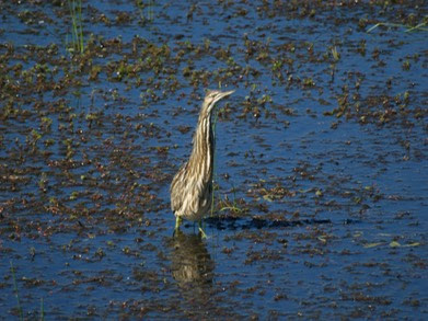
After spending the night in Susanville we continued south on Hwy. 395 and then west into the Sierra Valley. This is another notable Northern California birding spot that I had not visited. It is a broad wide open valley surrounded by forested mountains and includes both sagebrush and marshlands created by the various headwater channels of the Middle Fork of the Feather River. In the valley we met a very friendly group from Golden Gate Audubon and they told us about what they had been seeing. Our best bird here was an American Bittern who showed off for all of us. We also had good looks at White-faced Ibis and more of those great Yellow-headed Blackbirds. We probably would have seen more here if we had arrived earlier in the day. From here we headed west on Hwy. 49 up to the top of Yuba Pass where we stopped for a short hike that gave us a Red-breasted Sapsucker and a nesting Mountain Chickadee. A short way down the west slope we stopped for lunch with some Yellow-rumped Warblers at a nice spot along the river and that concluded our birding activities for this adventure. I really enjoyed the drive down 49 even though it was narrow and twisty. The Yuba River Canyon is steep and rugged and really quite spectacular. The towns of Sierra City and Downieville are like stepping back into California's history and will require a return visit in the near future. All in all we had a great trip and I look forward to a return to the Modoc Plateau and Warner Mountains next June.
No comments:
Post a Comment